
The single-engine Airbus H125 helicopter is used for many different missions.
Aviators share a common core requirement even though their missions and operating environments contain vast differences. They must be adept at proactively identifying risks and formulating strategies to mitigate those risks. While the two accidents described below could segue into a wide spectrum of important safety topics, a key common element that will be the focus of this article is risk assessment.
On Feb. 22, 2022, two UH-60 Black Hawk helicopters from the Utah National Guard were performing winter mountain training. The mission included landing the helicopters in a tight formation simultaneously on a mountainside. The intended landing spot was within a short walking distance of the ski lifts in the high mountain bowl of the Snowbird ski resort. An abundance of skiers was on the slopes that day partaking in the fresh, light snow that had fallen previously.
A helicopter at a slow speed, such as during hover or landing, is generating high-velocity downwash. As the two Black Hawks flared to land, the immense rotor downwash quickly created a whiteout.
A degraded visual environment is a serious and well-known risk. A pilot can experience a total loss of outside reference when rotor wash causes loose dirt, sand or snow to whip around the rotorcraft. The pilot is unable to see nearby objects to provide the outside visual references necessary for aircraft control near the ground.
Once inside the cloud of snow or dust, crews are vulnerable to excessive sink rates, lateral drift and obstacle collisions. It interferes with the pilot’s ability to maintain geospatial awareness of the intended landing point. It can cause spatial disorientation as the blowing sand, dust or snow creates the illusion of a tilted horizon. Blowing sand or snow around the cockpit windows can also lead the pilot to experience “vection illusion,” where the helicopter appears to be turning when it is actually in a level hover. These can cause the pilot to make incorrect control inputs.
The trailing Black Hawk drifted slightly to the right and subsequently rolled onto its side. The main rotor blades broke apart. A piece of the main rotor struck the adjacent helicopter’s tail rotor. The damage to the second helicopter’s tail rotor negated its ability to counter the torque from the main rotor, resulting in a complete spin.
The pilot of the second Black Hawk was able to land in the soft snow with no serious injuries in a feat of laudable handling skills under extreme conditions. The cost of damages to both helicopters was estimated at $9.23 million. It is also fortunate that the high-velocity debris from the disintegrating main rotor blade did not strike any of the nearby skiers standing in the ski lift line.
Astute readers who follow aviation accidents may recognize that this unit had another accident nearly two years later when an F-35 pilot, who had only 35 min. of experience in an AH-64 Apache simulator, was allowed to take the controls of an Apache while attempting to hover at the end of an orientation flight under the supervision of a chief warrant officer in the accompanying seat.
The F-35 pilot, who was a colonel in a nearby Air Force Reserve unit, reverted to his fixed-wing training and applied an inappropriate control movement during a hovering attempt. The Apache was destroyed and the colonel suffered serious injuries that required surgery and extensive rehabilitation.
The subsequent investigation highlighted the F-35 pilot’s lack of qualifications as well as the pilot-in-command’s inadequate flight control management. The report also criticized the unit’s chain of command for failing to adequately enforce standard operating procedures, citing similar leadership failures in the 2022 accident. The investigation raised questions about the adequacy of current safety measures and oversight within the National Guard unit.
Flight Risk Assessment Tool
Is there a formal checklist in civilian aviation to help pilots proactively and systematically identify areas of possible risks and highlight hazards in need of mitigation? The answer is yes.
The FAA has constructed a Flight Risk Assessment Tool (FRAT) that is user-friendly and free to use online. One of the strengths of the FAA tool is that it recognizes the tendency for a pilot to become fixated on an individual risk. This can lead to overlooking other risks, as well as the cumulative collection of other risks.
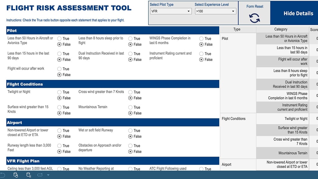
The FRAT includes the general categories of Pilot, Flight Conditions, Airport, VFR Flight Plan, IFR Flight Plan and Approaches. For example, the Pilot category asks quick questions about the pilot’s flight currency, sleep, dual instruction within the last 90 days, completion of a WINGS Pilot Proficiency Program phase and instrument currency and proficiency.
The online worksheet is simple to use, quickly tabulates the accumulated risk points and provides an easy-to-understand green-yellow-red color coding to give the pilot a visual indication of the risk level of the flight—a tool that applies well to the general aviation pilot.
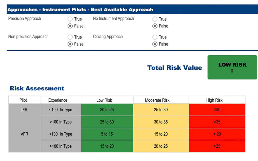
The FRAT concept applies equally well to business aviation as to general aviation. A well-designed FRAT can provide proactive identification of specific risks as well as the accumulation of risk for the flight. In addition, FRAT fits well into a Safety Management System (SMS), which will become mandatory for most of the industry within a couple years.
Each operator should take the opportunity to custom-design a FRAT for their pilot experience, qualifications and training, the mission, aircraft operating characteristics and the flight environment. Operators should consider that some factors carry more risk and should receive more points in the risk calculation.
Approach And Landing Awareness
The Flight Safety Foundation’s Approach and Landing Accident Reduction (ALAR) awareness tool is worth integrating into an organization’s FRAT. Let us expound on this.
For example, is the pilot familiar with the destination? Some might wonder why this is important. Unfamiliarity increases human error by 17 times according to the research conducted by psychologist James Reason. ALAR doubles the risk weighting for this parameter.
The ALAR tool doubles the risk points for pilot fatigue. Here is the caveat with pilot self-assessment of the fatigue level: Nearly every in-depth study on pilot fatigue has noted that pilots consistently underrate their level of fatigue and alertness. Eventually we as an industry need to implement a better method that has undergone thorough scientific review to objectively assess a pilot’s fatigue and alertness.
The Airport category needs to be customized for the specific type of aircraft. For instance, a proficient flight crew flying a straight-wing Citation has a sufficient safety margin flying into Hilton Head Airport, but jets that require longer landing distances are not compatible with this location. The runway length parameter should include a comparison of the predicted landing distance for the forecasted weather and runway surface conditions versus the runway’s actual length and width.
The ALAR tool doubles risk for crosswind, gusts, tail wind and wind shear. The combination of crosswinds with a slippery runway increases the risk, especially with a narrower runway. This parameter also may need heavier weighting for aircraft that have tighter crosswind limitations. I would also suggest adding the parameter of density altitude in the category of aircraft or airport environment conditions.
Accurately predicting the effects of wind, temperature and runway surface conditions is vital to every takeoff and landing. There are many reasons why the actual runway environmental conditions can vary significantly from the reported values. This uncertainty increases risk.
The ALAR tool doubles the risk score for lack of current local weather reports, as well as for adverse runway conditions to include ice, slush, snow or water. Business aviation often operates into a wide spectrum of airports, many of which are non-towered and have limited resources. ALAR triples the risk for this parameter.
Runways at many business aviation destinations do not include features such as crowning, grooves and porous filled concrete to minimize the pooling of water. This category should receive extra points when the likelihood of precipitation exists.
The assessment of the approaches needs to be considered with respect to the weather as well as the adjacent terrain. For example, a 2,000-ft. ceiling and 3-statue-mi. visibility is rather unremarkable in terms of risk at a midwestern airport served with an instrument landing system and surrounded by flat terrain, but that weather is below minimum at many airports in the Rocky Mountains.
Non-precision approaches create higher risk, especially with step-down procedures or circling. ALAR triples the risk for this category. A visual approach in darkness is given double points by the tool.
Does the pilot have the training and qualifications if the destination fits the concept of a Special Qualification Airport? Many business aviation destinations truly fit this definition, and flight crews need to be trained to be proficient and current on location-specific procedures.
ALAR assigns double points to the risk for a destination surrounded by adverse terrain. Frankly, some airports visited by business aviation should receive even higher risk ratings, especially the mountain bowl locations with high-density altitudes and challenging approach and departure procedures.
The powerful visual illusions caused by heavy rain or blowing snow have tricked many flight crews into landing short of the threshold. Several notable business aviation destinations have unusual runway slopes that create a pronounced visual illusion on the landing approach. ALAR doubles the risk if visual illusions are present from sloping terrain, a wet runway, whiteout or snow.
The post-maintenance test flight accident involving a Hawker 900XP on Dec. 20, 2023, and the Apache helicopter mishap cited earlier are indicative that post-maintenance test flights, orientation flights and flight instruction contain their own unique risks and should utilize customized FRATs.
Helicopter Operations
Helicopter operations are distinctly different from fixed-wing, and a FRAT should be modified for the helicopter’s operating environment.
Two clear areas in which a FRAT for helicopters should be modified are off-airport landing zones and the risk from deteriorating weather. Unfortunately, both contain a preponderance of unknown information that complicates flight risk assessment.
The threats at off-airport landing zones often include multiple unknowns, such as surface conditions, slope and lack of accurate wind information, as well as proximate obstacles like trees, light posts, bushes, high grass, fences, buildings, vehicles, people, livestock and almost-impossible-to-see thin wires.
It is standard risk assessment practice to establish a “high recon” orbit to perform an in-depth analysis of an off-airport landing zone. The altitude, airspeed and flight pattern for the high recon will be governed by terrain and wind.
A commonly used acronym to remind a pilot of the necessary items to analyze is known as the AWOTFEEL check. It stands for: estimated Altitude of landing zone, Wind, Obstructions, Turbulence, Forced landing areas, Entry, Exit and Landing zone conditions. Once the pilot is satisfied that each of these critical parameters is safe, then a low orbit is conducted to do a closer evaluation of the landing approach and touchdown zone.
Companies that conduct flight operations in mountainous and snow-covered terrain have revised their risk controls. Pilots at Air Zermatt and heli-skiing operators are mentored by avalanche control specialists to learn about differences in snow composition, snow metamorphosis over time, how winds on windward zones will tend to remove snow from a ridgeline and deposit it in the leeward side, how snow on a southern-facing aspect will metamorphose differently than a north-facing slope and more.
A knowledge of the recent weather pattern is vital, too. A warm spell during the daytime followed by cold temperatures at night will tend to form a crust on the surface of the snow. Yet a fresh snowfall on top of such a crust, especially if the snowfall is light powder, will create a double threat. The loose powder will quickly create a whiteout as soon as the rotor wash hits the surface, and once the helicopter finally settles onto the surface, the skids can get “caught” by punching through the underlying crust, creating the potential for a dynamic roll-over.
Several of these operators collaborate in training with first responders and ski patrol teams with the goal of elevating the skills of team members on the ground to better evaluate a potential landing spot for a rescue helicopter prior to a helicopter’s landing approach.
Another high-risk condition that has been problematic for helicopters is deteriorating weather. A 1988 NTSB study determined that the single most common factor in fatal emergency medical services helicopter accidents was unplanned entry into instrument meteorological conditions and most of these accidents occurred at night. During the preflight planning stage, pilots seldom had exact weather information for the destination.
Pilot decision-making was also complicated, with weather forecasts containing “chance of localized weather” conditions. Many air ambulance flights are to remote landing sites or to hospitals that do not have such weather reporting available.
This places a premium on a pilot’s ability to apply meteorological knowledge—trying to assess the influence of nearby water bodies, diurnal heating and cooling, the influence of topography, incoming weather fronts and other factors—all of which can have a localized effect on the weather.
This introduces a significant challenge to a pilot and realistically requires constant reevaluation during the flight. Some organizations have implemented formal “go no further” criteria in the form of airspeed reduction and/or height reduction in reaction to worsening weather.
For SMS purposes, the utilization of an Enroute Decision Point by a flight crew should be recorded for evaluation of the effectiveness of the implemented risk control strategies. By the way, this would integrate well into an SMS if your program has an Aviation Safety Action Program as well as Flight Data Monitoring.
Importance Of Reevaluation
Once you have custom-designed your own FRAT, consider utilizing a color-coding system to help users quickly identify which flights fall into the acceptable (green), additional mitigation required (yellow) or unacceptable (red) levels of cumulative risk. This will help to prioritize the flights that require mitigations by the pilots, dispatchers and aviation managers.
A tool is only productive if it is actually used, and that requires being user-friendly. Some of the commercially available FRAT programs automatically input important weather, terrain and runway conditions data prior to a flight. Pilots complete the FRAT by answering questions on their fitness that can be easily entered via a smartphone or tablet.
Several of these products automatically re-score the FRAT 1 hr. before departure with updates in the winds and weather. The tool will alert the pilots if there is a change that could negatively affect the flight’s risk.
Many times, the approach and runway surface conditions change during a flight due to quick-moving or convective weather. Professional pilots should be proficient in conducting a landing performance assessment to detect these changes from the preflight planning data and apply prudent risk mitigation for any significant changes.
A FRAT’s effectiveness can be increased when a dispatcher actively follows a flight because they have important information such as the latest information on the runway surface condition, weather and winds, as well as the software to quickly recompute the fuel needed for diversion to a suitable alternate.
Dispatchers readily have the software to compute the new landing distances and/or do the calculations for the crosswind component, not only for the original destination but for reevaluating the suitability of an alternate.
What should an operator do if the FRAT score for an individual flight rises into the equivalent of a yellow risk category? This is where a flight manager should become involved to propose proper mitigation measures that are consistent with the company’s safety policies. The intervening actions should be recorded for evaluation of the effectiveness of the implemented risk control strategies, as well as for the identification of new hazards.
Additionally, a company should have the proper processes to determine the need for new or revised risk controls. These are key elements of an SMS, which will become mandatory for Part 135 operators by May 28, 2027.

Related Content


